顯示具有 MapWindow GIS 標籤的文章。 顯示所有文章

2010年1月18日 星期一

MapWindows GIS Convert CSV File to Shape File

Most of Engineer get the X, Y value form site survey, something like collect the value form GPS. Today, I will share how to use MapWindow GIS(Free GIS software) to create the Shape File by CSV file.

1. Open the MapWindows GIS software, and click the "Converter->CSV to Shapefile".

2. The System will open the CSV to Shapefile Dialog, you can click the Browser icon form Input File.

3. Choose the CSV file and click "OK" for opening.

4. Click "Open File" and click "Point" for Data Type. Finally, click "Convert" to convert the CSV to Shapefile

5. You will see the Point data in the screen of MapWindows GIS.

2009年11月23日 星期一

MapWindow GIS軟體初探(一)

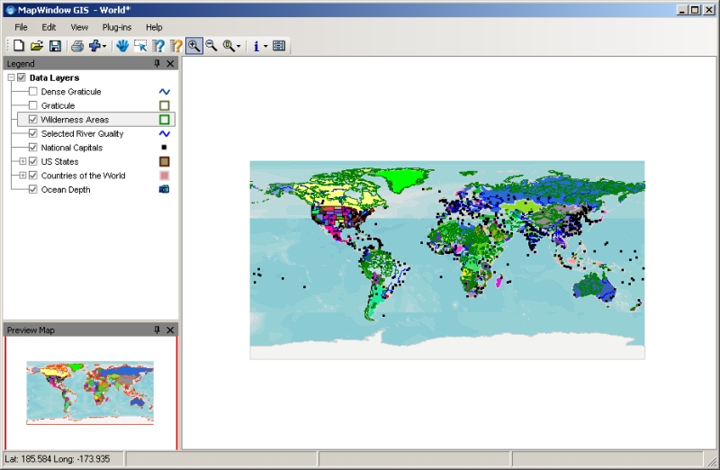
先前介紹了MapWindow GIS軟體時,僅分享了連結下載的位置,並沒有特別實際針對功能性去操作或是說明。這兩、三天測試了一些功能與閱讀了使用手冊,發現MapWindow GIS真的相當完整。當然,MapWindow GIS在國外已經有相當多的使用者再使用與加值,但是在國內卻比較少被介紹到,因此,想多花一些時間來介紹給國內的朋友們。

MapWindow GIS乍看之下,界面較一般使用的ESRI ArcView與MapInfo Pro簡單許多,很使用者可能會在這個地方打住,認為MapWindow GIS只是一般的開圖軟體,像是GAIA Viewer一樣。其實不然,MapWindow GIS相較於GAIA Viewer而言功能強大許多。其中,最特別的在於有許多付費與免付費的Plug-in程式可以提供使用。

在Plug-ins選單中,就羅列了目前已被開發出來的工具。其中部分使是需要付費的,例如:Shape2Earth這一個Plug-in(提供將Shape File發佈至Google Earth);但是像Shapefile Editor就是免費的。使用者在使用的時候,就會看到版權公告,了解視需要付費或是免費的工具。
就初步使用上的分享,筆者將MapWindow GIS與ESRI ArcViewc、MapInfo Pro作簡單的比較:
1. MapWindow GIS與ESRI ArcViewc、MapInfo Pro都具有相同的地圖顯示平台,操作上的方法與概念大致上是相同的。例如:圖層的加入,可以透過工具列上的"加號"來新增。
2. 在屬性資料的顯示上,三者也都有提供標準的屬性資料表,讓使用者可以瀏覽物件的屬性。當然,圖資互動性的查詢,也存在MapWindow GIS的屬性資料表中。
3. 於屬性資料的查詢上,MapWindow GIS與ArcView較為相似,都是利用性質條件來作運算與篩選查詢;而MapInfo Pro則是用SQL的語法。
4. 在Layout與Graphy(統計圖)上,明顯的MapWindow GIS比較缺乏這樣的展示能力。
5. 在編修上,MapWindow GIS主要提供ESRI Shape File檔案的編修,這也是MapWindow GIS教為支持的資料格式。

眾觀以上論點,在地圖展示、屬性資料查詢、圖形編修上,MapWindow GIS已經具有相當程度的GIS功能了;更值得加許的是在他免費且開放性的架構。
有關更多MapWindow GIS的操作與說明,請見:http://www.mapwindow.org/wiki/index.php/Main_Page

筆者將另闢專欄來討論MapWindow GIS軟體,也歡迎各位先進給與指教。

2009年11月16日 星期一

Free GIS Tools - MapWindow GIS Download

工欲善其事,必先利其器!
繼GAIA Viewer後,我又在網路上發現一個免費的GIS軟體,功能似乎比GAIA更加完整,而且一樣免錢!
會如此積極的尋找免費的GIS軟體並且分享給大家,無非是希望各位可以尊重版權,你沒有花錢,就去用免費的,千萬不要私自下載非法軟體。再者,要做防災應用,你一定要簡單的平台可以開啟一些免費的資料,製作防災地圖,所以,儘量使用低成本的工具。
We talk about Gaia Viewer before, today, I will share the "MapWindow GIS", it's more powerful and GIS free software. You can use the "MapWindow GIS" as same as ESRI ArcView! So, what are you waiting for? download today!
MapWindow GIS Downloadhttp://www.mapwindow.org/
MapWindow GIS下載位置請前往http://www.mapwindow.org/

Visit MapWindow GIS home page

you can easily find out the download page

Most of GIS software has the same UI, so, you can getting start easily.
所有的GIS軟體都有相同的界面與概念,所以相當容易入手!