In this article, you can learn how to use Civil 3D get the elevation data from Google Earth by Point Object. Besides, you can also learn the point data import/export.

原始資料包含點編號、名稱、經緯度資料,但缺乏高程值。因此,利用Google Earth與Civil 3D來建立點物件的高程。The source data include the point number, name, latitude, and longitude data in Microsoft Excel file.
利用GAMINE GPS軟體MapSource查詢座標資料後,可以查出點位的高程(這不是很準確的方式,但是可以應急),另外也可以將成果發佈置Google Earth中來觀看結果,如下圖。I create a reference data by MapSource(The GAMINE GPS desktop software) and publish to Google Earth. In this step, we can locate the point in Google Earth, and then Civil 3D can download the surface from Google Earth.

筆者希望可以再利用點位資料找到Google Earth中的高程資料,來作一個驗證與比對。因此,這時候就利用到Civil 3D的軟體,但是如何自動將Google Earth高程值對應到點為呢?這一點就是本篇文章的一個重點了,筆者想到,這一種練習也許可以幫助使用者去學習如何活用Civil 3D這樣的軟體。
筆者的解決方式思考邏輯如下:
If you want achive the goal that get the elevation from Google Earth by Civil 3D Point Object, you need consider about the following things.
1. 利用Civil 3D可以開啟Google Earth的地形,如果我可以將點位在建立起來,這時候就會有地形與點位的資料了。How to create point object and overlap in Civil 3D? Civil 3D can import Google Earth Source and point file.
2. 點位建立,原始資料是經緯度的,Civil應開可以將點位轉換成TWD97,或將地形也轉換為TWD97的,這樣一來就可以套疊了。How to Tranfrom the source data CS from Lat/lon to TWD97? If the Google Earth surface and point data within the same CS, it's can overlapping.
3. Civil 3D因該可以將點位附與地形高程。(這部分需要測試)How to get elevation from surface by Civil 3D?
4. 筆者是否可以將資料匯出成對應的格式,提供比對。How to export?
綜上所述,筆者利用Civil 3D建立了一系列的操作,如下:
A.建立一個新的格式的點檔案格式。這一個格式是CSV檔案,主要用來匯入EXCEL資料(當然筆者有對格式修改過);然後,他要能夠將經緯度的座標系統轉換為TWD97的座標系統(因為筆者再匯入Google Earth的DWG專案檔已經設定為TWD97座標系統,且GE資料已經匯入)。First step is create a new Point File Format in Civil 3D to help you import the source data. in this step, I create a CSV input and set the CS to LL84.
注意:筆者設定經緯度讀取的資料格式為DECDEG Latitude與DECDEG Longitude
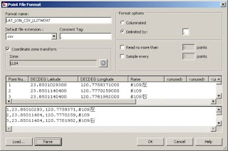
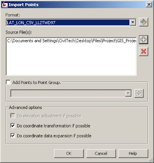
B.利用創建出來的點檔案格式讀取CSV檔案,這裡要注意的是要將下方的"Do Coordinate Transformation if Possible"勾選起來,這時候才會進行座標系統轉換。 When you import the point file, please click on the "Do Coordinate Transformation if Possible". Civil 3D will help you check the source data CS and current project CS and transform in the same CS automatically.
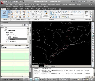
C.點位與地形套疊再一起了(由於Civil 3D匯入Google Earth地形資料的教學筆者以前文章已經發表過了,所以不再贅述)You can see the point date on the surface. I wont explain how to import Google Earth Surface by Civil 3D, cause we already discussed it before.
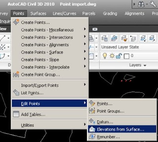
D. 將點位套疊並加入來自Google Earth地形的高程值,可以利用Point->Edit Point->Elevation from Surface選單來處理。If you want get the elevation value form Google Earth surface you can click the "Point->Edit Point->Elevation from Surface" from menu bar.
E. 之後點位資料就有來自Google Earth的高程值了。 Right now, you get the elevation form Google Earth Surface.
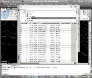
F. 最後就是將點位資料匯出為文字檔或其他格式作比對,方法就是建立一個新的點檔案格式,然後匯出。
注意:筆者設定經緯度讀取的資料格式為DECDEG Latitude與DECDEG Longitude,讀者也可以改用其他格式的輸出。Finally you can export the Point data to CSV file. As well as, you can create another Point File Format for export.
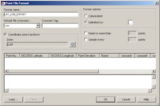
成果比對如下,大至上Google Earth與GAMIN牌GPS軟體MapSource還是有些許差異,但是原則上高程值並沒有太大的誤差值。
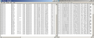
操作心得:
1. 讀者可以利用這樣的範例練習Civil 3D點位資料的匯入與匯出,並且建立自己需要的格式。
2. 此外,還可學習到如何利用Civil 3D轉換測點座標至別的座標系統。
3. 可以學習如何利用測點攫取地面高程。
4. 這是一個衍生的應用,如果使用者缺依些資料(粗略的資料),就可以用Civil 3D與Google Earth來建立作為參考。


沒有留言:
張貼留言